|
|

++ A b o u t K o r č u l a >> m a p
GEOGRAPHICAL POSITION :
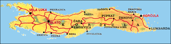
The central Dalmatian island of Korčula stretches parallel with the nearby mainland in the west-east direction. It is 46.8 km long, its average width is 5.3 to 7.8km, it covers an area of 270 km , and is the sixth largest Adriatic island. The Pelješac Channel, which separates it from Pelješac peninsula, is 1,270 m wide at its narrowest point.
Korčula is built of limestone and impermeable dolomite, and in places it retains rainwater in pools. The limestone areas are crisscrossed with chasms, pits and sinkholes. Karstic poljes (plains enclosed by steep walls) and small dry valleys with shallow fertile red soil (terra rossa) stretch down the middle of the island. In places there is sand (Lumbarda) or sandy clay (Blatsko polje). The relief supports the composition of the soil: about 90 percent of the island is hilly, but the hills do not exceed the height of several hundred metres. The highest peak Klupica (568 m) lies almost in the centre of the island between Pupnat and Cara villages. Next come Gradina (554m), Kom (510m),and Hum (377 m).
The island shoreline is 182 km long, and the shorelines of the nearby islets another 54 km. Korcula is very indented with a large number of bays and coves. Its north shore is rather low and easily accessible with several natural harbours sheltered from the jugo and easterly winds: Korčula, Banja, Račišće, Vrbovica, Babina, Prigradica. The south shore is more indented but steep in places, with cliffs rising up to 30m out of the sea in places. There are many anchorages and bays sheltered from the bura but open to the jugo: Zavalatica, Rasohatica, Orlanduša, Pavja luka, Pupnatska luka, Prižba, Grščica etc., and Brna is sheltered from both the bura and the jugo. The largest, best protected bay is Vela Luka in the furthest west of the island.
CLIMATE :
The island has a very mild Mediterranean climate. Mean temperatures are rather high: the mean annual temperature is 16.8°C, in the coldest month of January it is 9.1"C, in the hottest month of July 26.9°C. Daily and annual temperature differences are small, which is very favourable for agriculture and tourism. There are many hours of sunlight, 2,700. There is little rain, about 41 days during the year, mostly in autumn and winter, while late spring is usually a dry period interspersed with rare short-lasting storms. Snow is uncommon, when it does fall it falls first in Pupnat and the surrounding peaks but thaws quickly because the temperature rarely drops below 0"C. It is almost always windy in the Peljesac Channel. In summer the refreshing western maestral usually blows, good for sailing; in winter the south-easterly jugo, the cold northeasterly bura, or strong northerly tre-muntana.
Sea currents in the Peljesac Channel are rather weak, growing stronger only with the jugo. The average temperature of the sea surface in March is 12.9°C. It is the warmest in summer, in July, August and September, when it averages 22.3 C. Changes of the tide are small, the difference between high and low tide is about 50 cm.
|
|
 |
|